Whistler - Weather - Environment Canada

Friday, December 5, 2014

7cm overnight


The arctic outflow has come to a end and is being replaced by warmer air moving up from the southwest. Warm air will come in over top of entrenched cold air in the valley's bringing the possibility of freezing rain. Mainly cloudy skies with light precip on Saturday morning. Monday the first of a series of systems from the SW moves in bringing another round of copious precipitation and high freezing levels to the coast mountains. Wednesday's storm is looking like a very wet warm deep low. Not good for the ski hill...


Rain up top, freezing down low

Freezing rain warning in effect for:
Whistler

Ice build-up due to freezing rain is expected or occurring.

Arctic air remains trapped at low levels while bands of warm, moist air flows in from the Pacific at higher elevations. A mixture of snow and freezing rain will develop by this afternoon and continue through tonight. Precipitation will change to rain by Saturday morning.


Forecast

Today
Cloudy. Snow or freezing rain beginning late this morning.
Local snowfall amount 2 to 4 cm. 
High: 0 °C
Tonight
Cloudy. 40 percent chance of flurries this evening. Snow mixed with rain beginning near midnight. Risk of freezing rain this evening and overnight.
Local snowfall amount 2 to 4 cm.
Temperature steady near zero.
FL: rising to near 2000m
Precip: 6cm 
Low: 0 °C
Saturday
Snow mixed with rain changing to rain in the morning and ending late in the afternoon then cloudy. Risk of freezing rain early in the morning.
FL: Dropping to around 1500m
Precip: Nil
High: 3 °C
Sunday
Cloudy with 60 percent chance of showers.
FL: 1750m
Precip: 1cm
Low: 2 °C
High: 4 °C
Monday
Cloudy with 60 percent chance of showers.
FL: 1700m rising to 1900m
Precip: 15mm to 30mm
Low: 1 °C
High: 4 °C
Tuesday
Rain.
FL 1900m
Precip: 30mm-60mm
Low: 2 °C
High: 7 °C
Wednesday
Rain.
Heavy at times
FL 1900m rising to 2500m in evening
Precip: 60mm to 100mm
Low: 5 °C
High: 7 °C
Thursday
Rain.
FL: Too high
Precip: Get your rubber boots out

A weak system early Saturday morning

Tuesday night the first in a series of systems from the SW
Wednesday evening a deep low bringing in warm tropical air

And the freezing level goes through the roof. Go away El nino

Environment Canada is expecting the next three months to be average or warmer than normal in almost the entire country, thanks in part to El Niño


The NOAA forecasters say it's not quite a EL Niño
From the NOAA

The first Thursday of every month is when we do the CPC/IRI ENSO status update, when NOAA officially answers the question “Are we there yet?” This month, the answer is...close, but no cigar.

Sea surface temperatures (SSTs) in the Niño3.4 region of the Pacific were quite warm during November, with the most recent weekly Niño3.4 index value at +1.0°C above average. The threshold for El Niño conditions is +0.5° above average for one month, and most of the climate models are forecasting that SSTs will stay above average for at least a few more months. Then why haven’t we changed from an “El Niño Watch” (favorable for development of El Niño conditions) to an “El Niño Advisory” (El Niño conditions are present)?
The atmosphere just won’t get with the program

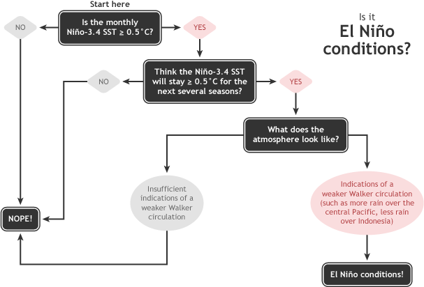
First, a quick review of what we mean by “El Niño conditions.” There are three components:

(1) A one-month SST anomaly of +0.5°C or greater in the Niño3.4 region (check!), 

(2) An expectation that the warm SSTs will meet or exceed that threshold for the next few months (seems very likely!), 

(3) An atmospheric response typically associated with El Niño (not quite there yet).
ENSO diagnostic flowchart
Low: 5 °C
High: 8 °C


Whistlerweather.org Station

Blog Archive